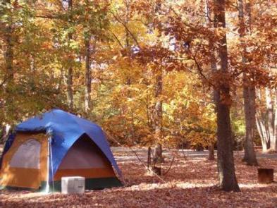
Patapsco Valley State Park sits on a wooded bluff above the Patapsco River valley, 20 minutes from Baltimore. The Hollofield area has 73 sites. Tent and RV. Spread across inner and outer loops beneath mature hardwoods. Electric hookups are available on the inner loop; outer sites are larger but non-electrified. Reservations fill weekends quickly.
Mixed-use campground with sites suitable for tent camping and RVs; inner electrified loop and outer non‑electrified loop provide different site types and sizes.
Weather and SeasonsFall delivers the campground's signature experience: brilliant hardwood color on the Patapsco River valley and comfortable hiking temperatures. Daytime highs are typically in the mid-50s to low 70s°F with crisp nights in the mid-30s to 50s°F, making long trail days and photography ideal. Leaf-peeping, biking the packed dirt trails, and quieter wildlife viewing are at their peak, though weekends can draw many day-trippers from Baltimore. Spring brings fresh green leaves and warming weather. Summer means firefly displays in June and opportunities to cool off in the river, though humidity climbs. Winter offers stark, quiet beauty and those distant views through bare branches.
Weather data by Open-Meteo.com, licensed under CC BY 4.0, processed by Outdoorithm.
Natural Features and SceneryThe campground occupies a forested bluff at 417 feet, with mature hardwoods creating thick canopy and natural privacy screens between sites. The Hollofield overlook provides sweeping views across the river valley. Over 70 miles of trails thread through the park. The Ole Ranger and Peaceful Pond trails stay on higher ground, while the Union Dam Trail descends to the Patapsco River itself. Cool water over smooth stones, good for wading and fishing. In summer the canopy filters sunlight into dappled patterns. In winter the bare branches open up distant river views you can't see when the leaves are on.
Geological RegionPatapsco River Valley (wooded bluff above the river valley).
Scenic ViewsHollofield overlook offers sweeping, seasonally changing views of the Patapsco River Valley—bright green in spring, colorful foliage in fall, and more open river views in winter when leaves are off the trees.
 4.23
4.23