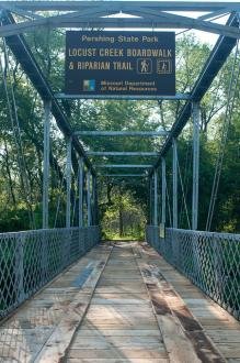
Pershing State Park Campground sits in north-central Missouri's bottomland forest and wet prairie landscape, 39 sites split across two loops with electric hookups, showers, and a dump station. The park's boardwalk and trail system weave through marsh, pond, and forest habitats that draw birders and quiet-seeking campers. Most sites are shaded and well-spaced; expect mosquitoes near the wetlands in summer and occasional highway noise on a few tent sites.
Campground contains a mix of electric sites and more basic/primitive sites in two loops; sites accommodate both tent campers and RVs with 30-amp electric connections available at many sites.
Historical Significance
The park is named for General John J. Pershing, who was born nearby. Visitors commonly combine a camping trip with a stop at the John J. Pershing Boyhood Home State Historic Site in Laclede. The park also preserves remnants of Missouri's once-extensive wet prairie and savanna ecosystems, regionally significant habitats that have largely disappeared from the state.Weather and SeasonsFall delivers the clearest benefits: crisp, comfortable weather (daytime highs often 55–75°F in September–October, cooler mornings) and dramatic color in the bottomland forest that makes hiking and wildlife viewing outstanding. Water levels typically stabilize for boating and fishing, mosquitoes are much reduced, and the park sees fewer campers than midsummer so trails and boardwalks feel quiet. Autumn migration and late-season shorebird movement boost birding, while cooler temps make multi-mile hikes easier. Spring brings waves of migrating songbirds that fill the wetlands with music and trail weather that's generally pleasant. Summer turns everything lush and green but comes with heavy mosquitoes near wetland areas and higher humidity. The campground stays open year-round; winter use is possible but expect a quiet experience with potentially limited interpretive programming and weather-related constraints.
Weather data by Open-Meteo.com, licensed under CC BY 4.0, processed by Outdoorithm.
Natural Features and SceneryThe campground occupies a rare slice of Missouri's wet prairie and bottomland forest at 761 feet elevation. A wooden boardwalk floats above living marsh where great blue herons hunt, wood ducks slip between cypress knees, and dragonflies work the mirror-still water. Four small lakes and countless ponds anchor the landscape, rimmed by bottomland hardwoods and wet prairie grass. The scenery is intimate rather than sweeping. Views from the boardwalk look out over marsh and prairie; longer trails offer extended walks through forest and savanna rather than high overlooks. Creeks meander past oxbow sloughs, and the forest canopy reflects cleanly in the water below.
Geological RegionNorth-central Missouri (wet prairie and bottomland forest landscape)
Scenic ViewsIntimate, close-in scenery: wooded and shaded campsites, boardwalk views over wet prairie and marsh, and small pond or creek views near some campsites. Longer trails provide extended views across prairie and bottomland forest rather than high overlooks.
 4.42
4.42