Toadstool (Ne) Nebraska Nf

Star4.61
471 reviews
Toadstool (Ne) Nebraska Nf
Top 4%Fall
Romantic GetawayScenic ViewsGreat Hiking

Real-Time Availability

Select a month, then check for open campsites

S
M
T
W
T
F
S

Quick Facts

3,783 ft

Price

$15/night

Booking

Check Site

Sites

12 campsites

Season

Year-round

Cell

Unknown

Pets

Check Policy

Get Directions
Toadstool (Ne) Nebraska Nf
$15.00 - $15.00 / night
Campsite Fees
ScanPay 1: $15.00. Plus Recreation.gov reservation transaction fee ($8 online / $9 phone / $3 in person).
No paid fee categories listed.

Get Notified When Available

We'll monitor this campground and alert you the moment sites become available.

Free to start · paid plans add 2-min scans

256,000+ sites monitored · Email, SMS, or in-app notifications

Learn more about alerts →
Share this campground
Recreation Dot Gov
Provider
N/A
I manage this campground

Campground Map

Toadstool (Ne) Nebraska Nf

Toadstool (Ne) Nebraska Nf

42.8581, -103.5839

Nearby places
Hot Springs, SD — 37 miles (to intersection with Toadstool Road)
Crawford, NE — directions provided via Highway 2 (4.2 miles to Toadstool Road) then 11.4 miles on Toadstool Road and 1.4 miles on FS Road 902 to the campground.

Weather at Toadstool (Ne) Nebraska Nf


About Toadstool (Ne) Nebraska Nf


I manage this campground

Planning your trip?Check out our camping packing checklist


Go if

Geology nerds, photographers, and families with kids who can handle easy trails will get the most out of this place. The one-mile interpretive loop works for ages 6 and up, the shade covers on six of the twelve sites help in heat, and the uncrowded quiet is real.

Skip if

Any rain in the forecast should make you reconsider entirely, reviewers describe the dirt road and trails turning dangerously slippery when wet. No water on site means hauling everything in, and there's no camp store for 15 miles of gravel in either direction.


Campgrounds
Toadstool (Ne) Nebraska Nf

From the U.S. Forest Service

Reference information about Toadstool (Ne) Nebraska Nf sourced from official USFS records and forestcamping.com. View official recreation.gov page →

Overview

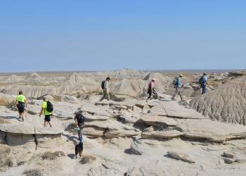
<p>Toadstool Geologic Park is noted for its unusual geological formations, some in the shape of toadstools, and scientifically valuable fossil deposits. Our interpretive kiosk explains and illustrates the local geology and provides information and history about the local grasslands. During your hike look for signs of fossils that give scientists insight into the behavior of animals as they passed through this area as far back as 30 million years ago. In order for others to enjoy viewing these fossil resources collection is prohibited.</p><p>The trailhead at the campground provides access to three hiking trails to choose from with varying degrees of difficulty.&nbsp;A one mile loop highlights many examples of eroded clay/sandstone formations. While on the trail, follow our <a href="http://www.fs.usda.gov/Internet/FSE_DOCUMENTS/fseprd1084809.pdf">interpretive brochure</a> to learn the fascinating geology of the area.</p><p>The Bison Trail leaves the interpretive loop at the half way point and continues up the canyon to <a href="https://www.fs.usda.gov/recarea/nebraska/recarea/?recid=10621">Hudson-Meng Education and Research Center</a>.&nbsp;Toadstool Campground to Hudson Meng is 3 miles one way.</p><p>&nbsp;A five mile loop begins at the campground and proceeds on the graveled section of the interpretive trail for a short distance before heading north through the badlands and grasslands on the Great Plains Trail.&nbsp;After 1.5 miles the Great Plains Trail intersects with the 918 Road.&nbsp;Follow the signs to return to the Bison Trail and Toadstool Campground. The loop can be done in reverse going the other direction on the interpretive trail as you leave the campground.</p><p>The Great Plains Trail developed by the Great Plains Trail Alliance is a cross country network of public land trails and roads beginning in Guadalupe National Park and ending at the Canadian Border. The Bison Trail, 918 Road and part of the 5 mile loop are part of this network. Great Plains Trail information can be found at <a href="http://www.greatplainstrail.org/">www.greatplainstrail.org</a> &nbsp;</p><p>The campground consists of six sites with picnic tables and fire rings and upright grills and two accessible vault toilets. <strong>There is no water.&nbsp;</strong></p><p><strong>Special features</strong>:&nbsp;In 1984 the Forest Service constructed a sod house near the site of a sod house built in 1929.&nbsp; The new &quot;soddie&quot; provides a look into the past when the homesteaders on the grasslands used the only abundant material available. The original sod house was lived in briefly before being abandoned and signs of the original structure no longer exist.</p><p>Fossils and artifacts are protected under federal laws.</p>

About the campground

The elevation is 3,800 feet. The campground is a single loop next to the geologically interesting Toadstool Park. Each site has excellent views of the Toadstool formations and surrounding grasslands. The understory is grass that is kept mowed giving the campground a manicured appearance. The mowed grass gives two benefits. First, it reduces the risk of an accidental wildfire and, more importantly, offers some protection from the Prairie rattlesnake. Although there is no middlestory, privacy is excellent due to the space between campsites. A ramada (sun shade) over the picnic table and pedestal grill is located at each campsite. The campground is excellent for a 360 degree view of the night sky and is centrally located for day trips to Hudson-Meng Bison Bonebed, High Plains Homestead, Warbonnet Monument, and Montrose Church. Of course, the Toadstool Geologic Park trail is a must while at this campground - amazing. Oglala National Grassland 265

Seasons & access

Services provided May 15 through November 15

RV information

The parking aprons are gravel.

Directions

In Crawford, NE, at the intersection of State Routes 2/71 and US Route 20, take Routes 2/71 north 16.6 miles to second Toadstool sign. Turn left after sign onto Sugarloaf Rd. (gravel, single-lane with few turnouts) and go 6.5 miles to another Toadstool sign. Turn left at sign onto Toadstool Rd (gravel and dirt) and go 2 miles to campground sign. Turn right after the sign onto gravel road, crossing railroad tracks, and go 1.3 miles into campground. NOTE: Toadstool Rd. can be very rough, with serious washboarding and potholes, south of the campground. Alternative (shorter but not recommended for recreational vehicles): In Crawford, NE, at the intersection of State Routes 2/71 and US Route 20, take Routes 2/71 north 4.6 miles to Toadstool sign. Turn left after sign onto Toadstool Rd. (gravel and dirt) and go 12 miles to campground sign. Turn left after the sign onto gravel road, crossing railroad tracks, and go 1.3 miles into campground.

National Forest
Roosevelt National Forest
Ranger District
Pine Ridge
Rate
$5 per day
Maximum Stay
14